Post by diceycat on Dec 4, 2021 8:10:51 GMT -5
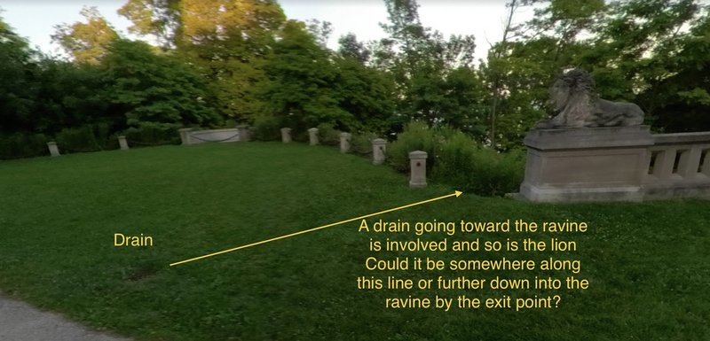
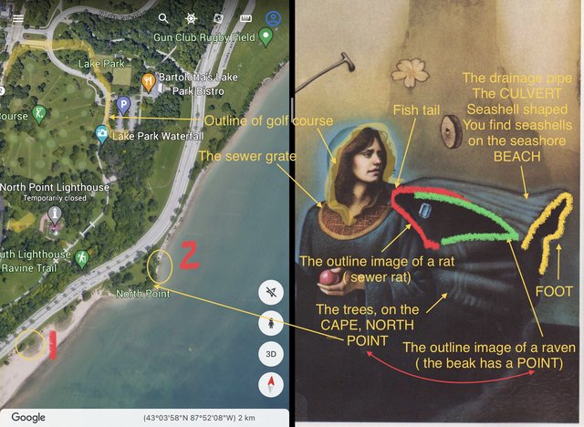
The problem lies in which trail you choose. If you choose the North light house ravine trail ( makes the most sense) why would he say go south east unless there was a split in the trail from the bridge , then probe the exit point of the drainage pipe labeled “1” .If the ravine trail exit is a different trail then the location of the drainage pipe exit would be different. The reason why I say this is because in the painting the drainage pipe is depicted as being above or north of the Cape. Even though it’s part of the Cape.This could also be interpreted as drainage for the north point or close by and that’s all. I think when he says to pass 3 ( light poles),staying west then count the 5 more after that then that sewer cover by the 8th light pole dumps into the number 1 spot. Not sure if there are other drainage outlets on the embankment that I can’t see.
I posted a possible second (#2)location to check . Not even sure if there is a drainage exit there on that section of land. If worse comes to worse then check the drainage exit between #1 and the north point Cape. If still nothing then go for the most southern drainage exit on the beach.
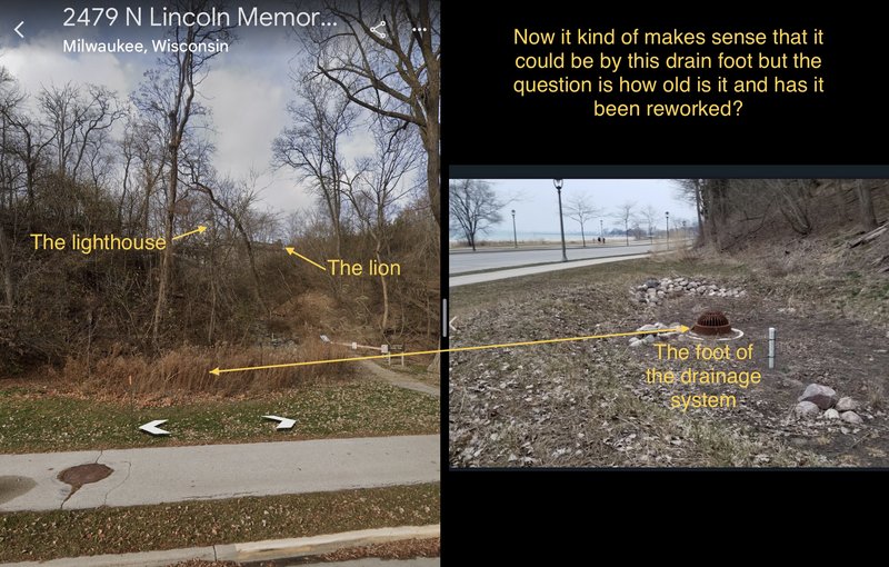
Another reason for thinking that the “southern foot “ relates to the drainage exit is that the word foot is mentioned in the verse in conjunction with the word culvert in the one of the verse lines “ below the foot of the culvert “
Now in the painting, that dark area at the end of what I call the culvert looks like a foot ( see the foot in the Boston solve touching the home base on the sleeve).
There are several possibilities.
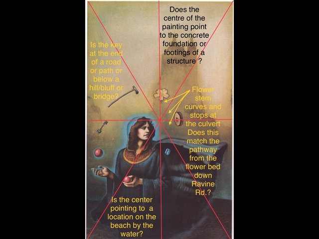
I like the fact that in the first three casques that were found the location fell directly in the centre of the painting
So if we assume this is true for all the other paintings then that Center point could be the base or footings or foundation of a tall stone/ concrete structure or the position of the culvert on Ravine Drive or possibly the beach.

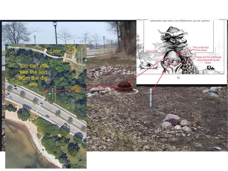
The casque could also be at the south foot of one of the lions as well
Im going to add more. I strongly feel that all the objects that the girl is juggling surrounds Ravine road and not the Lion bridges even though the bridge plays a part. The painting is a map with the central point being the final location. There have been so many changes over the years in the park that the clues ( verse lines) ,might not make sense any longer.
I personally think the casque is along Ravine road on the north side .
I see from some photos that the exit points of some of these older culverts are cast concrete. They may have done work on these culverts over the years and possibly the casque is destroyed or there may be pieces of it scattered about close by.
I would check for those exit points and see if they are still there or remnants of concrete .
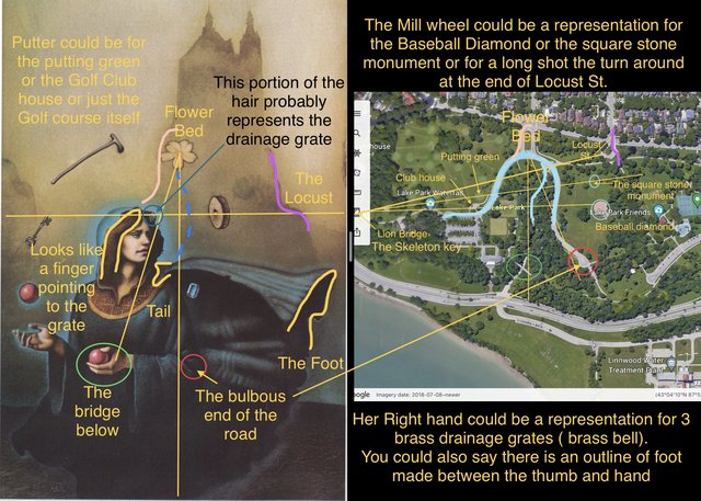
Another problem is the Mill Stone in the painting and it’s location relative to the Locust and the top of the girls head.
So there are 3 possibilities.1: It represents the Baseball diamond ( ( it was there in 1981j
2: It represents the square stone monument for the burial ground( it’s been there since 1910)
3: It represents the turn around at the end of Locust. St.( it’s been there for a very long time and the lines when drawn suit the map and painting best)
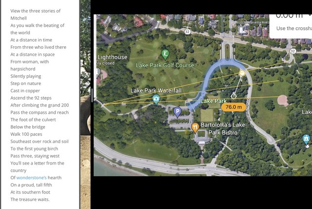
Either way, I would check ( you might even want to use a GPS for accuracy), along all three of those lines drawn as they cross Ravine Road to see is if a culvert is or was there. To me it makes sense that he would want to try to bury the casque discreetly.
I also think that any thing with blue around it means there is a close association with water. The blue around the head could be for Lake Park Rd. and the blue around the lone red ball in the painting could be for the sewer manhole cover that’s at the top end of Ravine Rd. ( which could be the foot of the culvert ,the bridge below once you pass the compass which could just be the arc in the Lake Park road by definition).
Anyways , a few more pics.
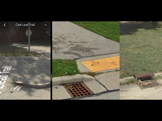
Some of the storm grates you see in the pics below have changed in style and some don’t even exist today. So that may throw off some of the verse clues.
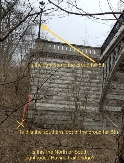
I still think the proud tall 5th is the raised flower bed since in the painting the flower has 5 petals.
Now in the pic below I have corrected some of my line bearings ( the bridge below , (the hand holding the red ball) ,on painting is not directly South of the flower bed but more SW even though on the map the bridge is directly below (East ), of the flower bed
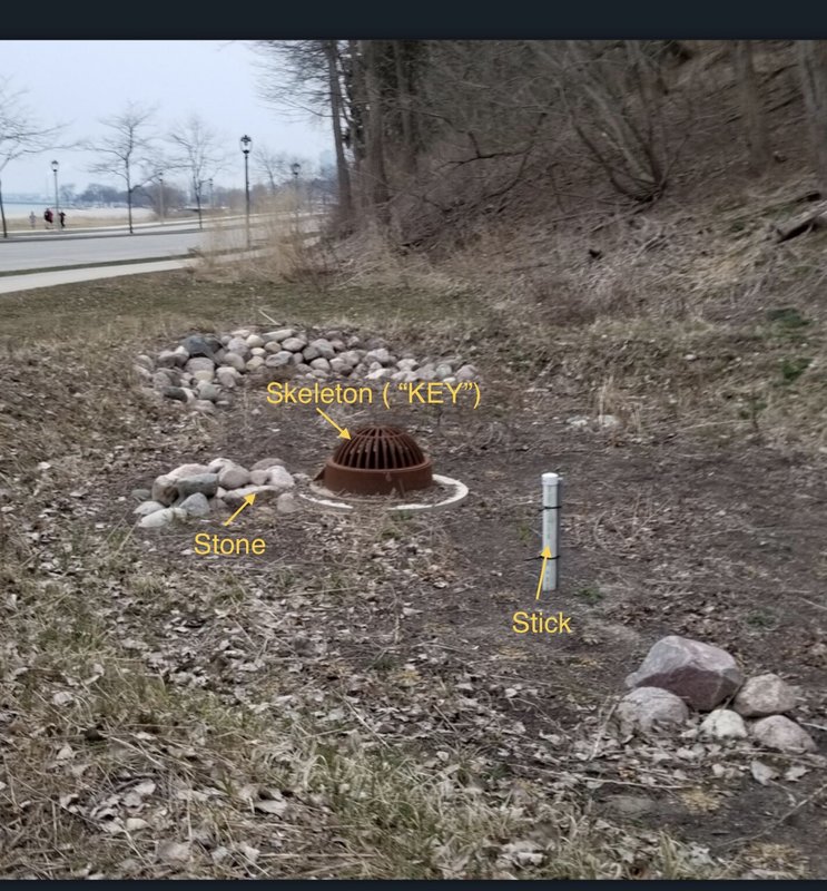
Another problem I have is the foot , Is it the drainage grate entrance or the discharge exit point? From what I can find the exit point of a culvert is called the tail.
GLTA
I posted a possible second (#2)location to check . Not even sure if there is a drainage exit there on that section of land. If worse comes to worse then check the drainage exit between #1 and the north point Cape. If still nothing then go for the most southern drainage exit on the beach.
Another reason for thinking that the “southern foot “ relates to the drainage exit is that the word foot is mentioned in the verse in conjunction with the word culvert in the one of the verse lines “ below the foot of the culvert “
Now in the painting, that dark area at the end of what I call the culvert looks like a foot ( see the foot in the Boston solve touching the home base on the sleeve).
There are several possibilities.
I like the fact that in the first three casques that were found the location fell directly in the centre of the painting
So if we assume this is true for all the other paintings then that Center point could be the base or footings or foundation of a tall stone/ concrete structure or the position of the culvert on Ravine Drive or possibly the beach.
The casque could also be at the south foot of one of the lions as well
Im going to add more. I strongly feel that all the objects that the girl is juggling surrounds Ravine road and not the Lion bridges even though the bridge plays a part. The painting is a map with the central point being the final location. There have been so many changes over the years in the park that the clues ( verse lines) ,might not make sense any longer.
I personally think the casque is along Ravine road on the north side .
I see from some photos that the exit points of some of these older culverts are cast concrete. They may have done work on these culverts over the years and possibly the casque is destroyed or there may be pieces of it scattered about close by.
I would check for those exit points and see if they are still there or remnants of concrete .
Another problem is the Mill Stone in the painting and it’s location relative to the Locust and the top of the girls head.
So there are 3 possibilities.1: It represents the Baseball diamond ( ( it was there in 1981j
2: It represents the square stone monument for the burial ground( it’s been there since 1910)
3: It represents the turn around at the end of Locust. St.( it’s been there for a very long time and the lines when drawn suit the map and painting best)
Either way, I would check ( you might even want to use a GPS for accuracy), along all three of those lines drawn as they cross Ravine Road to see is if a culvert is or was there. To me it makes sense that he would want to try to bury the casque discreetly.
I also think that any thing with blue around it means there is a close association with water. The blue around the head could be for Lake Park Rd. and the blue around the lone red ball in the painting could be for the sewer manhole cover that’s at the top end of Ravine Rd. ( which could be the foot of the culvert ,the bridge below once you pass the compass which could just be the arc in the Lake Park road by definition).
Anyways , a few more pics.
Some of the storm grates you see in the pics below have changed in style and some don’t even exist today. So that may throw off some of the verse clues.
I still think the proud tall 5th is the raised flower bed since in the painting the flower has 5 petals.
Now in the pic below I have corrected some of my line bearings ( the bridge below , (the hand holding the red ball) ,on painting is not directly South of the flower bed but more SW even though on the map the bridge is directly below (East ), of the flower bed
Another problem I have is the foot , Is it the drainage grate entrance or the discharge exit point? From what I can find the exit point of a culvert is called the tail.
GLTA