|
|
Post by Jenny on Oct 8, 2019 12:24:39 GMT -5
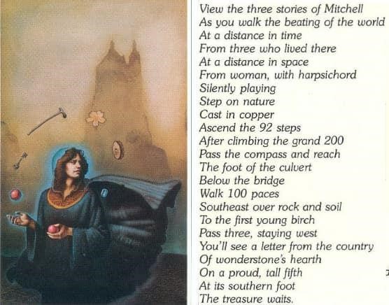
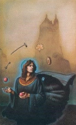
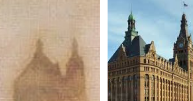
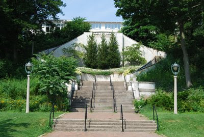
What are the main clues in the image (10) and verse (8) that make searchers believe a Secret Casque is buried in Milwaukee?  First Image 10: the lady is juggling items, some of which are a Mill stone, Walking Stick, and a Key... for MIL- Wal- Key or Milwaukee:  Next there is an outline of prominent location seen in the image: Milwaukee's city hall  This image, leading to Milwaukee, then connects to Verse 8 with it's 'Ascend 92 steps' (92 steps of the Grand Staircase in Lake Park)  These and other clues discovered provide a strong base that a casque will be found in Milwaukee.... More locations in threads here on forum, on video below, or here: mysteriouswritings.com/where-are-the-casques-of-the-secret-treasure-hunt-by-byron-preiss-thought-to-be-buried-and-why/ |
|
|
|
Post by canuck on Oct 9, 2019 17:42:00 GMT -5
A few more clues for Milwaukee/Lake Park:
If you look at the base of the city hall feature in the image there is a fairly obvious set of eyes. They look animal, are located in the darker space with the much lighter space coming down between the set of eyes…honestly reminds me of a badger.
Next to the mill stone is an object most call the "locust". In my opinion that is actually a human kidney, drawn like you'd find in an anatomy textbook. Erastus B. Wolcott has been credited with the 1st ever successful removal of a diseased kidney.
The "fair folk" category match for Milwaukee is Mugwumps.
Notice the teeth in the lower right portion of Mugwumps jaw. They spell “WI” the abbreviation for Wisconsin.
Next look at Mugwumps left side of the mouth and you will see the horse leg and hoof. This is a clear hint to the Erastus B. Wolcott statue.
There is also the "pretzel gavel" on page 146.
Pretzels are of German origin and Milwaukee has deep German roots.
The base of the Wolcott statue was designed by Albert Ross. Ross also happens to be the same person who constructed the Milwaukee County Courthouse, so that gavel makes a whole lot of sense.
The "southern foot" would be the front right hoof of Gunpowder, Wolcott's horse.
If you look at the statue today the whole front half of the statue is surrounded by brick paver stones. Generally these stones aren’t set into the ground very deep, but they are impeding recovery of the casque.
Any idea how long those brick paver stones have been there? If they pre-date the early 1980s it would point to the casque being at the rear right side, but my understanding is the rear portion of the Wolcott statue has been dug up extensively over the years.
Thoughts on this being the casque burial site?
|
|
|
|
Post by choice on Jun 11, 2020 0:55:25 GMT -5
|
|
davem
Full Member
  
Posts: 190
|
Post by davem on Nov 8, 2020 13:44:41 GMT -5
Choice (and anyone else interested) but Choice has helped me out so many times on the 13th casque search so I'm aiming this suggestion in your direction:
I'm heading to Milwaukee for Thanksgiving week. I know that there has been considerable searching in the area below the footbridge in Lake Park but I certainly plan on going there to have a look around while I'm there. The birch trees are all gone and any sign of the "letter from wonderstone's hearth country" is now supposedly gone. But I'm sure gunna have a look. If there are any alternative location ideas or if you'd like some specific angle for a picture, please let me know. I'll repeat this on one of the other main pages.
|
|
|
|
Post by choice on Nov 9, 2020 1:59:52 GMT -5
There are a couple of other spots deserve checking out. "Proud, tall fifth" may refer to the 5th lion on the lion bridges. "At its southern foot" if he's referring to the lion and since lions don't have feet, may be a reference to "south paw" or it's left paw. Here are the 5th and 6th lions: goo.gl/maps/bag5sbonEPNFJRCy6The lion closest to the lighthouse is interesting since it's left paw is in an unexposed spot. Another interesting spot is the waterfalls fountain below the bridge/culvert. I was looking for running water since I believe the "millstone" in the image is actually a watermill. If you look closely at the image you may see the equally spaced blades around the circle to catch water. Also people on top of the culvert may throw or "cast in" pennies for good luck! goo.gl/maps/P3d2PbFo7Us4tyub8goo.gl/maps/aVi8pMrGhjnrjSEd7Even though it was originally built in 1930's, it was completely redone by 2010. |
|
|
|
Post by byrnietuney on Nov 9, 2020 4:23:54 GMT -5
While there, run your fingers over the faint writing carved under the southernmost lion - there's some discussion started in 2011 by WhiteRabbit, as to whether quest4treasure.co.uk/phpbb3/viewtopic.php?f=32&t=3000&p=113207&hilit=kupper#p113207you'll see a letter which is perhaps a german umlaut 'ü' within the name of P. Kupper carved there. The writing is too weathered to tell by any picture, it might be able to be judged by feel and eye. Take stout walking footwear so you can examine the area from where the treeline starts southwest of the southernmost Lion, along to the lightpost and about half the same distance past it, particularly from the top of and down the slope a bit from there. I.E.; goo.gl/maps/AFto8e4UHN3qFmcy9You can see the lion Bridge at the left of that picture. Thats Oct 2019 - the slope undergoes periods of junglization, they clear it out periodically. This is May 2009; goo.gl/maps/BUw4vz4yY3grcEpa9You can see that area about the top of the slope isn't too steep; goo.gl/maps/9dbpUM8QkKWwndtT7Maybe kick around a bit to see if any stumps are hiding below the layers of leaf litter. Optimally, you'd video that area along the top of the slope and the slope just down a bit from the top. Don't video too long or loiter too long to be seen from N Wahl Av, as the Milwaukee Grandees that inhabit the mansions overlooking the park have a habit of summoning der polizei if they see any activity in the park they don't approve of. I'm quite serious. Cheers |
|
|
|
Post by choice on Nov 9, 2020 16:23:51 GMT -5
There are a bunch of clues to the golf course area though.
Red tee markers and the potter (cane) and even the watermill (waterfalls) next to the bug (culvert) pointing to the waterfalls which is right next to the golf course across the trail. Or it could just be the general area indicator.
|
|
davem
Full Member
  
Posts: 190
|
Post by davem on Nov 9, 2020 17:24:15 GMT -5
While there, run your fingers over the faint writing carved under the southernmost lion - there's some discussion started in 2011 by WhiteRabbit, as to whether quest4treasure.co.uk/phpbb3/viewtopic.php?f=32&t=3000&p=113207&hilit=kupper#p113207you'll see a letter which is perhaps a german umlaut 'ü' within the name of P. Kupper carved there. The writing is too weathered to tell by any picture, it might be able to be judged by feel and eye. Take stout walking footwear so you can examine the area from where the treeline starts southwest of the southernmost Lion, along to the lightpost and about half the same distance past it, particularly from the top of and down the slope a bit from there. I.E.; goo.gl/maps/AFto8e4UHN3qFmcy9You can see the lion Bridge at the left of that picture. Thats Oct 2019 - the slope undergoes periods of junglization, they clear it out periodically. This is May 2009; goo.gl/maps/BUw4vz4yY3grcEpa9You can see that area about the top of the slope isn't too steep; goo.gl/maps/9dbpUM8QkKWwndtT7Maybe kick around a bit to see if any stumps are hiding below the layers of leaf litter. Optimally, you'd video that area along the top of the slope and the slope just down a bit from the top. Don't video too long or loiter too long to be seen from N Wahl Av, as the Milwaukee Grandees that inhabit the mansions overlooking the park have a habit of summoning der polizei if they see any activity in the park they don't approve of. I'm quite serious. Cheers Ok will do! Wow, I'll be as quick as I can. |
|
davem
Full Member
  
Posts: 190
|
Post by davem on Nov 9, 2020 17:26:47 GMT -5
There are a couple of other spots deserve checking out. "Proud, tall fifth" may refer to the 5th lion on the lion bridges. "At its southern foot" if he's referring to the lion and since lions don't have feet, may be a reference to "south paw" or it's left paw. Here are the 5th and 6th lions: goo.gl/maps/bag5sbonEPNFJRCy6The lion closest to the lighthouse is interesting since it's left paw is in an unexposed spot. Another interesting spot is the waterfalls fountain below the bridge/culvert. I was looking for running water since I believe the "millstone" in the image is actually a watermill. If you look closely at the image you may see the equally spaced blades around the circle to catch water. Also people on top of the culvert may throw or "cast in" pennies for good luck! goo.gl/maps/P3d2PbFo7Us4tyub8goo.gl/maps/aVi8pMrGhjnrjSEd7Even though it was originally built in 1930's, it was completely redone by 2010. "South paw" very clever. Will do! I thought Lincoln was great for cast in copper but literally "cast in" copper into the water is even better. |
|
|
|
Post by choice on Nov 9, 2020 18:46:59 GMT -5
Also it's generally accepted that "compass" is the North Point Lighthouse. However if you consider compass as the Masonic compass, you know the tool that you draw a circle with then there are lamp posts on top of the Grand Staircase that have those electrical junction boxes. See if you can find others! Also checkout McKinley compass/windrose!!! goo.gl/maps/jGN8WZUsK8o7rJfd8 |
|
davem
Full Member
  
Posts: 190
|
Post by davem on Nov 10, 2020 11:03:35 GMT -5
Also it's generally accepted that "compass" is the North Point Lighthouse. However if you consider compass as the Masonic compass, you know the tool that you draw a circle with then there are lamp posts on top of the Grand Staircase that have those electrical junction boxes. See if you can find others! Also checkout McKinley compass/windrose!!! goo.gl/maps/jGN8WZUsK8o7rJfd8 Actually, I thought the Masonic compass was the generally accepted one. I'll check around for more for sure! |
|
|
|
Post by choice on Nov 10, 2020 12:28:54 GMT -5
North Point Lighthouse was used by Renner on EU TV show to get to the southern most lion. Similarly by others to get below the bridge. Masonic looking sign was mentioned on Wiki (where I stole the image!) and haven't seen a convincing solution around it. Not for the lions location. It may work with the waterfall. Any clues to what this thing is at the right edge of the image? It seems truncated. I wish we had access to the original painting. My best guess is it may be the North Point Water Tower; perhaps a nudge to N.P. Lighthouse.  |
|
davem
Full Member
  
Posts: 190
|
Post by davem on Nov 10, 2020 17:41:49 GMT -5
Also it's generally accepted that "compass" is the North Point Lighthouse. However if you consider compass as the Masonic compass, you know the tool that you draw a circle with then there are lamp posts on top of the Grand Staircase that have those electrical junction boxes. See if you can find others! Also checkout McKinley compass/windrose!!! goo.gl/maps/jGN8WZUsK8o7rJfd8Just wondering --- why would the lighthouse be considered to be "a compass"? Beside roundness, I can't think of any other traits they have that are similar. And it looks like there are 8 lions in total. Are the Northern most two considered to be numbers 1 & 2? Is that considered to be 100 paces from the waterfall down that path? |
|
|
|
Post by byrnietuney on Nov 10, 2020 17:48:09 GMT -5
Choice said; "Any clues to what this thing is at the right edge of the image?" I consider it possible that some of the photographs that BP provided to JJP looked something like this 1987 photo; bridgehunter.com/photos/12/01/120181-M.jpgThat's standing on the north Lion Bridge looking ~south - you need to imagine the similar view as if you were standing south of the south Lion Bridge looking ~north. That gives you the apparent 'pommel' and also the 'handgrip', the apparent upward curve on the 'handguard' may be somewhat an effect of pixellation, or perhaps in ~1981/82 they had let the grass grow over the concrete somewhat - here's a picture (from the 2014 truck incident) of the north end of the south bridge; hips.hearstapps.com/vidthumb/e3dbf012-240a-413e-8f3b-4c21448fcea3/e3dbf012-240a-413e-8f3b-4c21448fcea3_image.jpgwhere, if we look at the grass in line with the nose of the truck and then imagine in ~1981/82 if they had let the grass grow too much over the concrete as the grass progressively approached the stone bal ustrades to the right of the truck, then you might get that apparent curve. The way the top of the image seems to come to a 'sharp point' is difficult to explain - pixellation again? Could be.
|
|
davem
Full Member
  
Posts: 190
|
Post by davem on Nov 10, 2020 18:08:40 GMT -5
There are a couple of other spots deserve checking out. "Proud, tall fifth" may refer to the 5th lion on the lion bridges. "At its southern foot" if he's referring to the lion and since lions don't have feet, may be a reference to "south paw" or it's left paw. Here are the 5th and 6th lions: goo.gl/maps/bag5sbonEPNFJRCy6The lion closest to the lighthouse is interesting since it's left paw is in an unexposed spot. Another interesting spot is the waterfalls fountain below the bridge/culvert. I was looking for running water since I believe the "millstone" in the image is actually a watermill. If you look closely at the image you may see the equally spaced blades around the circle to catch water. Also people on top of the culvert may throw or "cast in" pennies for good luck! goo.gl/maps/P3d2PbFo7Us4tyub8goo.gl/maps/aVi8pMrGhjnrjSEd7Even though it was originally built in 1930's, it was completely redone by 2010. Have you noticed the writing on the tree in the waterfall 360 image? |
|